

The data observed in the control networks of the Segura River Basin Authority, both in terms of quality and quantity, are used to calibrate the results of the models.
DSS
The main objective of the decision support information system is to integrate all the data obtained through the continuous monitoring system, in situ sampling, and remote sampling (measure 8.1), the hydrogeological and diffuse pollution characterization of the catchment basin (measure 8.2), and the modeling of biogeochemical processes and their effect on the lagoon's biota (measure 8.3). The data flow produced within measures 8.1 and 8.3 will be established from the digital platform developed within measure 8.1. Once the information is collected, this tool will help convert it into useful information that aids management and the ongoing evaluation of the actions implemented in the catchment basin and the Mar Menor lagoon, in order to understand the combined effect on reducing the different pressures and improving the state of the lagoon. This evaluation must be prospective in order to decide on additional measures to be taken.
Simulated data
Comprehensive hydrological modeling of the Mar Menor drainage basin
SWAT+ GWFLOW ECO-HYDROLOGICAL MODEL
Simulation of the water balance, both surface and underground, of the watershed draining to the Mar Menor.
After calibration, different application scenarios of the MAPMM measures will be simulated and their effectiveness in reducing pressures will be evaluated.
Hydrodynamic modeling of the Mar Menor coastal lagoon
SYMPHONY THREE-DIMENSIONAL MODEL OF OCEAN CIRCULATION
The dynamics of the Mar Menor are reproduced using the SYMPHONIE model, which allows us to simulate the internal circulation of the lagoon, its stratification, and the exchanges with the Mediterranean Sea.
ECO3M-S BIOGEOCHEMICAL MODEL
This model is coupled with the three-dimensional physical model of ocean circulation, and simulates the circulation, thermodynamics and biogeochemical cycles in the ocean; the tool used is the ECO3M-S software.
What scenarios are raised in the models
The Mar Menor DSS is a tool that integrates the results of simulations of mathematical models based on different scenarios.
Since it has been shown that degradation phenomena in the Mar Menor are linked to the contribution of rainfall and torrential events, two main scenarios have been defined for this DSS, the first based on the application of MAPMM measures in different precipitation subscenarios and a second scenario of potential application of other complementary measures independent of climatic phenomena.
What data is modeled
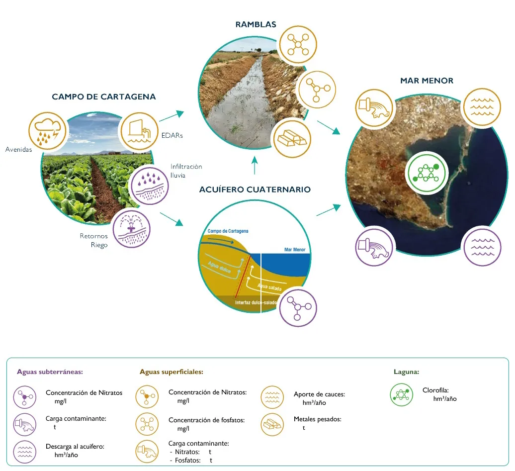
Data obtained from the monitoring networks of the competent agencies, which identify the anthropogenic pressures that have jeopardized the value and continuity of the Mar Menor ecosystems, such as excess nutrients and organic matter.
What models are used
The DSS of the Mar Menor integrates two large modeling blocks that jointly represent the functioning of the basin and the lagoon

WATERSHED MODEL
The SWAT ecohydrological model is used for surface waters, integrated together with GWFLOW for groundwater.
The surface water model aims to quantify the flow reaching the Mar Menor under natural conditions. This is achieved using a hydrological tool that simulates the movement of water, soil, and nutrients within the watershed.
It allows for the evaluation of the impact of land use, management practices, and precipitation scenarios. SWAT provides results such as river flows and runoff, soil erosion, sediment transport, nutrient losses (nitrogen and phosphorus), water quality (including pollutants and pesticides), and the effectiveness of conservation and agricultural management measures.
The groundwater model aims to quantify and analyze nitrate transport through groundwater to the Mar Menor lagoon. The model used is GWFLOW, a module coupled to SWAT, which simulates groundwater flow in three dimensions within a watershed.
It allows us to visualize how water moves underground, how it interacts with rivers, and how it responds to changes in soil, climate, or water withdrawals. It helps us understand groundwater levels, aquifer recharge, and potential impacts on groundwater availability.

LAGOON MODEL
Two integrated models of hydrodynamic and biogeochemical processes are used in the lagoon.
- The hydrodynamic process model. The SYMPHONIE model is used, which simulates water movement, vertical mixing, and exchanges with the Mediterranean Sea, allowing for a detailed and realistic representation of the lagoon's internal circulation, its stratification, and the hydrodynamic response to different atmospheric and oceanic forcings.
The biogeochemical processes model aims to simulate natural mechanisms involving essential chemical elements that circulate and transform among the biosphere, geosphere, hydrosphere, and atmosphere. These processes control how nutrients are produced, transformed, and transported within the lagoon's ecosystems.
The ECO3M-S tool is used, which is coupled with the three-dimensional physical model of ocean circulation, and simulates the circulation, thermodynamics and biogeochemical cycles in the ocean.